欢迎访问《中国农学通报》,
中国农学通报 ›› 2025, Vol. 41 ›› Issue (29): 38-45.doi: 10.11924/j.issn.1000-6850.casb2025-0210
郭镒维1( ), 张永颖2, 高子航3, 范春梅3()
收稿日期:2025-03-10
修回日期:2025-09-10
出版日期:2025-10-22
发布日期:2025-10-22
通讯作者:
作者简介:郭镒维,男,1984年出生,云南昆明人,高级工程师,学士,研究方向:生产建设项目水土保持。通信地址:650205 云南省昆明市盘龙区北京路2196号附1号,Tel:0871-65210000,E-mail:boyone1548@163.com。
基金资助:
GUO Yiwei1(), ZHANG Yongying2, GAO Zihang3, FAN Chunmei3()
Received:2025-03-10
Revised:2025-09-10
Published:2025-10-22
Online:2025-10-22
摘要:
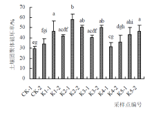
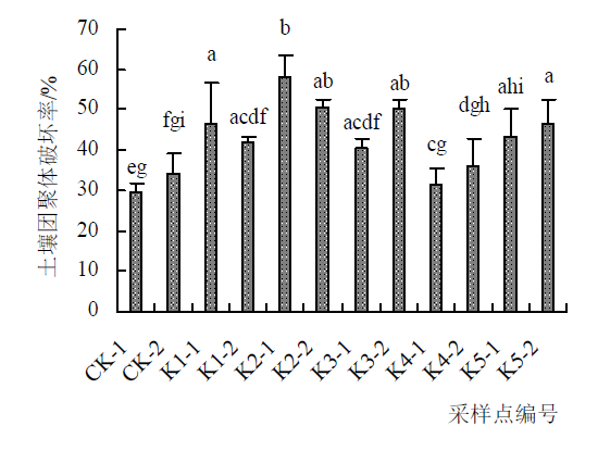
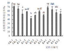
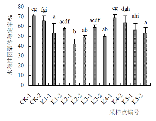
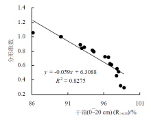
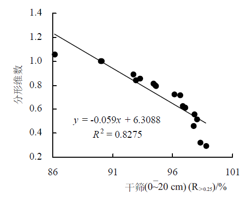
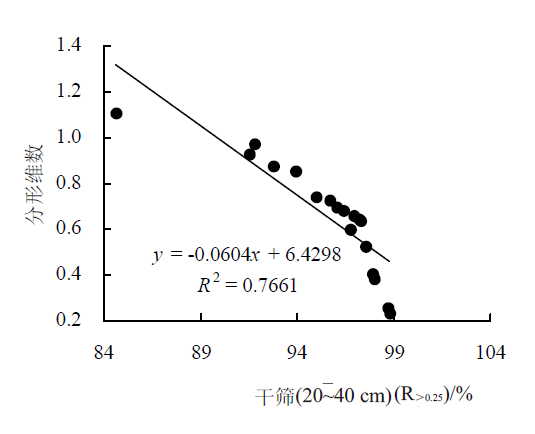
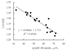
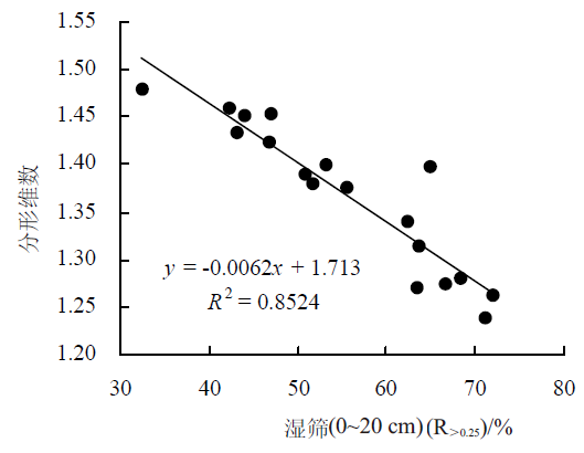
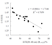
矿山开采迹地的土壤团聚体状况对生态修复措施的选择与配置起到重要作用,本文以滇东露天矿山开采迹地为研究对象,在独石山矿山选取5块典型开采迹地和1块未扰动区域作为对照,采集土壤样品,旨在探明开采迹地土壤团聚体稳定性及其分形维数特征。结果表明:矿山开采活动显著改变了土壤机械团聚体和水稳性团聚体分布;影响了土壤团聚体平均重量直径(MWD)、几何平均直径(GMD)和>0.25 mm粒级团聚体含量(R>0.25);降低了土壤结构稳定性,开采迹地2个土层的土壤团聚体破坏率(PAD)均高于CK采样点,而水稳性团聚体稳定率(WASR)均低于CK采样点,分别增加/降低1.88~28.66个百分点;开采迹地干、湿筛法下土壤团聚体分形维数均随>0.25 mm土壤团聚体含量的增加而减少。因此,可通过提高>0.25 mm土壤团聚体含量来降低分形维数,进而增加土壤结构稳定性。本研究揭示了矿山开采迹地的土壤团聚体稳定性与分形特征,可为矿山生态修复措施的选择与配置提供理论基础。
郭镒维, 张永颖, 高子航, 范春梅. 矿山开采迹地土壤团聚体稳定性及分形特征研究[J]. 中国农学通报, 2025, 41(29): 38-45.
GUO Yiwei, ZHANG Yongying, GAO Zihang, FAN Chunmei. Study on Stability and Fractal Characteristics of Soil Aggregates in Mine Spoil Areas[J]. Chinese Agricultural Science Bulletin, 2025, 41(29): 38-45.
| 采样点/试验处理编号 | 经纬度 | 海拔/m | 平均坡度/° | 坡长/m | 采样点/个 | |||||
|---|---|---|---|---|---|---|---|---|---|---|
| CK | 103°44′44″ E,25°40′15″ N | 2120 | 0 | — | 5 | |||||
| K1 | 103°44′44″ E,25°40′15″ N | 2100 | 30 | 13.8 | 5 | |||||
| K2 | 103°44′48″ E,25°40′12″ N | 2100 | 50 | 15 | 5 | |||||
| K3 | 103°44′47″ E,25°40′13″ N | 2110 | 42 | 9.8 | 5 | |||||
| K4 | 103°44′52″ E,25°40′12″ N | 2092 | 36 | 4.5 | 5 | |||||
| K5 | 103°44′45″ E,25°40′15″ N | 2100 | 0 | — | 5 | |||||
| 采样点编号 | 土层深度/cm | >5 mm | 2~5 mm | 1~2 mm | 0.5~1 mm | 0.25~0.5 mm | <0.25 mm | |||||
|---|---|---|---|---|---|---|---|---|---|---|---|---|
| CK | 0~20 | 34.67a | 34.92ah | 9.22 a | 11.86 aeh | 4.93 a | 4.40 a | |||||
| 20~40 | 42.56af | 29.97ag | 6.75 befg | 10.24 adf | 5.43 a | 5.04 a | ||||||
| K1 | 0~20 | 38.81ag | 30.96 ag | 7.67 aef | 12.14 ae | 5.61 a | 4.80 a | |||||
| 20~40 | 54.55bf | 26.00 bg | 5.60 cef | 7.50 fgh | 3.30 ac | 3.04 a | ||||||
| K2 | 0~20 | 37.47ah | 33.32 ai | 7.55 aef | 10.97 aef | 5.10 a | 5.60 a | |||||
| 20~40 | 50.44cfgh | 30.40 ag | 5.94 befh | 7.00 bdf | 2.83 ac | 3.40 a | ||||||
| K3 | 0~20 | 28.41 a | 27.06 cgi | 7.80 af | 15.19 e | 10.25 b | 11.28 b | |||||
| 20~40 | 29.92 a | 26.77 dgi | 8.09 agh | 15.30 e | 10.03 b | 9.89 b | ||||||
| K4 | 0~20 | 70.92di | 17.40 ej | 2.95 d | 4.33 bgij | 2.01 c | 2.39 a | |||||
| 20~40 | 77.87ei | 14.29 fj | 2.25 d | 2.59 ci | 1.34 c | 1.67 a | ||||||
| K5 | 0~20 | 38.88ah | 41.06 h | 5.48 e | 8.26 afj | 3.35 ac | 2.97 a | |||||
| 20~40 | 35.35ah | 38.16 hi | 6.79 befh | 10.09 af | 4.94 a | 4.66 a | ||||||
| 采样点编号 | 土层深度/cm | >5 mm | 2~5 mm | 1~2 mm | 0.5~1 mm | 0.25~0.5 mm | <0.25 mm |
|---|---|---|---|---|---|---|---|
| CK | 0~20 | 0.32 a | 12.71 ace | 10.86 a | 29.78 a | 13.94 a | 32.38 a |
| 20~40 | 1.86 ac | 18.85 a | 7.99 b | 22.20 ac | 11.71 a | 37.39 ac | |
| K1 | 0~20 | 3.34 ab | 11.12 c | 3.50 cgh | 16.67 cde | 16.10 ab | 49.28 be |
| 20~40 | 4.99 bc | 4.20 bde | 4.08 cd | 24.76 adf | 18.35 ac | 43.62 bcij | |
| K2 | 0~20 | 4.37 bc | 2.94 be | 2.04 e | 12.16 beg | 18.20 ac | 60.29 de |
| 20~40 | 5.77 bd | 4.02 bde | 2.71 ce | 18.22 cfgh | 17.03 ad | 52.27 bdf | |
| K3 | 0~20 | 3.15 acd | 9.18 bc | 5.36 d | 19.29 cfgh | 15.60 ae | 47.43 cfgk |
| 20~40 | 2.73 acd | 6.12 bce | 4.71 dg | 14.40 cg | 17.07 ae | 54.96 efh | |
| K4 | 0~20 | 3.99 acd | 10.07 cd | 7.51 b | 30.01 a | 15.36 a | 33.06 ai |
| 20~40 | 3.01 acd | 7.29 bce | 5.48 d | 24.92 adhi | 22.20 bcdef | 37.10 agj | |
| K5 | 0~20 | 1.37 ac | 2.16 e | 2.35 eh | 23.88 adhi | 25.22 f | 45.02 bchj |
| 20~40 | 1.31 ac | 1.93 e | 2.00 ef | 21.21 cfi | 24.55 cf | 49.00 bhk |
| 采样点编号 | 土层深度/cm | 干筛法 | 湿筛法 | ||||||||||||||
|---|---|---|---|---|---|---|---|---|---|---|---|---|---|---|---|---|---|
| MWD/mm | GMD/mm | R>0.25/% | MWD/mm | GMD/mm | R>0.25/% | ||||||||||||
| CK | 0~20 | 3.21ad | 2.46ace | 95.60a | 0.98abd | 0.63ab | 67.62a | ||||||||||
| 20~40 | 3.39ae | 2.58ac | 94.96a | 1.18b | 0.68a | 62.61ab | |||||||||||
| K1 | 0~20 | 3.26afh | 2.43ace | 95.20a | 0.92abd | 0.53ac | 50.72ce | ||||||||||
| 20~40 | 3.80befg | 3.14ad | 96.96a | 0.82acd | 0.49bcd | 56.38bcf | |||||||||||
| K2 | 0~20 | 3.27agi | 2.46ace | 94.40a | 0.66def | 0.39ce | 39.71d | ||||||||||
| 20~40 | 3.75agj | 3.09ad | 96.60a | 0.80acd | 0.45ce | 47.73cd | |||||||||||
| K3 | 0~20 | 2.67d | 1.69ce | 88.72b | 0.88abef | 0.51bcd | 52.57bcgh | ||||||||||
| 20~40 | 2.73dhi | 1.80e | 90.11b | 0.73acdf | 0.44ce | 45.04cdeg | |||||||||||
| K4 | 0~20 | 4.25bcj | 3.72bd | 97.61a | 1.03ab | 0.63ad | 66.94af | ||||||||||
| 20~40 | 4.46c | 4.08b | 98.33a | 0.85abdf | 0.53ade | 62.90afhi | |||||||||||
| K5 | 0~20 | 3.55ag | 2.94a | 97.03a | 0.57cf | 0.42ce | 54.98bci | ||||||||||
| 20~40 | 3.31ag | 2.55ae | 95.34a | 0.54cg | 0.40ce | 51.00c | |||||||||||


| [1] |
林杰, 张阳, 朱艳芳, 董波, 等. 淮北土石山区不同土地利用方式对土壤团聚体组成的影响[J]. 中国农业科技导报, 2019, 21(4):133-142.
doi: 10.13304/j.nykjdb.2018.0207 |
| [2] |
陈琳, 王健, 宋鹏帅, 等. 降雨对坡耕地地表结皮土壤水稳性团聚体变化研究[J]. 灌溉排水学报, 2020, 39(1):98-105.
|
| [3] |
祁迎春, 王益权, 刘军, 等. 不同土地利用方式土壤团聚体组成及几种团聚体稳定性指标的比较[J]. 农业工程学报, 2011, 27(1): 340-347.
|
| [4] |
王文鑫, 王文龙, 郭明明, 等. 黄土高塬沟壑区植被恢复对沟头土壤团聚体特征及土壤可蚀性的影响[J]. 中国农业科学, 2019, 52(16):2845-2857.
doi: 10.3864/j.issn.0578-1752.2019.16.010 |
| [5] |
卢金伟, 李占斌. 土壤团聚体研究进展[J]. 水土保持研究, 2002, 9(1):81-85.
|
| [6] |
韩贞贵, 毛天旭, 屠丹, 等. 长江源区草地覆盖变化对土壤团聚体分布及稳定性的影响[J]. 草地学报, 2020, 28(3):801-807.
doi: 10.11733/j.issn.1007-0435.2020.03.026 |
| [7] |
董亚辉, 戴全厚, 邓伊晗, 等. 喀斯特山区退耕地水稳性团聚体演变特征及土壤养分效应[J]. 水土保持通报, 2010, 30(2):138-141.
|
| [8] |
林立文. 喀斯特区植被恢复对土壤有机质组分及团聚体稳定性的影响[D]. 南宁: 广西大学, 2021.
|
| [9] |
董天富, 邓志豪, 杨静, 等. 喀斯特退耕地不同植被恢复阶段土壤团聚体稳定性特征[J]. 水土保持研究, 2024, 31(2):33-42.
|
| [10] |
任荣秀, 杜章留, 孙义亨, 等. 华北低丘山地不同土地利用方式下土壤团聚体及其有机碳分布特征[J]. 生态学报, 2020, 40(19):6991-6999.
|
| [11] |
|
| [12] |
|
| [13] |
李娟, 廖洪凯, 龙健, 等. 喀斯特山区土地利用对土壤团聚体有机碳和活性有机碳特征的影响[J]. 生态学报, 2013, 33(7):2147-2156.
|
| [14] |
崔芯蕊, 张嘉良, 王云琦, 等. 甘肃小陇山林区不同林分对土壤团聚体稳定性的影响[J]. 水土保持学报, 2021, 35(4):275-281.
|
| [15] |
章明奎, 何振立. 成土母质对土壤团聚体形成的影响[J]. 热带亚热带土壤科学, 1997, 6(3):198-202.
|
| [16] |
王磊, 刘晴廙, 史经攀, 等. 平原沙土区河岸带不同植被类型对土壤团聚体稳定性的影响[J]. 水土保持研究, 2024, 31(1):96-104.
|
| [17] |
赵文智, 刘志民, 程国栋. 土地沙质荒漠化过程的土壤分形特征[J]. 土壤学报, 2002, 39(6):877-881.
|
| [18] |
李阳兵, 魏朝富, 谢德体, 等. 岩溶山区植被破坏前后土壤团聚体分形特征研究[J]. 土壤通报, 2006, 37(1):51-57.
|
| [19] |
王国梁, 周生路, 赵其国. 土壤颗粒的体积分形维数及其在土地利用中的应用[J]. 土壤学报, 2005, 42(4):545-550.
|
| [20] |
王凯, 那恩航, 张亮, 等. 阜新露天煤矿排土场边坡土壤团聚体稳定性及分形特征[J]. 干旱区研究, 2021, 38(2):402-410.
doi: 10.13866/j.azr.2021.02.11 |
| [21] |
张大鹏, 范少辉, 蔡春菊, 等. 川南不同退耕还竹林土壤团聚特征比较[J]. 林业科学, 2013, 49(1):27-32.
|
| [22] |
杨培岭, 罗远培. 用粒径的重量分布表征的土壤分形特征[J]. 科学通报, 1993, 38(20):1896-1899.
|
| [23] |
|
| [24] |
盖小刚, 胡小兰, 张光灿. 沂蒙山林区不同植物群落下土壤颗粒分形特征[J]. 山东林业科技, 2010(2):9-13.
|
| [25] |
孙哲, 王一博, 刘国华, 等. 基于多重分形理论的多年冻土区高寒草甸退化过程中土壤粒径分析[J]. 冰川冻土, 2015, 37(4):980-990.
doi: 10.7522/j.issn.1000-0240.2015.0109 |
| [26] |
关添泽, 于萌, 卢刚, 等. 基于分形维数的不同发育阶段胡杨对土壤理化性质的影响[J]. 江苏农业科学, 2020, 48(20):293-300.
|
| [27] |
黄安, 谢贤健, 周贵尧, 等. 内江市微地形条件影响下土壤团聚体稳定性及分形特征[J]. 水土保持研究, 2012, 19(6):77-81.
|
| [28] |
苟天雄, 刘韩, 帅伟, 等. 川西高寒山地不同海拔高度土壤团聚体特征[J]. 水土保持研究, 2020, 27(1):47-53.
|
| [29] |
刘美龄, 叶勇, 曹长青, 等. 海南东寨港红树林土壤粒径分布的分形特征及其影响因素[J]. 生态学杂志, 2008(9):1557-1561.
|
| [30] |
李叶鑫, 吕刚, 王道涵, 等. 煤矿复垦排土场裂缝区土壤团聚体分布及稳定性[J]. 灌溉排水学报, 2023, 42(6):104-110,134.
|
| [31] |
吴宪, 张婷, 王蕊, 等. 化肥减量配施有机肥和秸秆对华北潮土团聚体分布及稳定性的影响[J]. 生态环境学报, 2020, 29(5):933-941.
doi: 10.16258/j.cnki.1674-5906.2020.05.009 |
| [32] |
杨卫君, 惠超, 陈雨欣, 等. 生物质炭施用下灌溉农田土壤团聚体稳定性及分型特征[J]. 水土保持学报, 2022, 36(6):323-329.
|
| [33] |
张海廷, 时延庆. 山东省不同土地利用方式土壤颗粒组成及其分形维数特征[J]. 水土保持研究, 2018, 25(1):126-131,138.
|
| [34] |
姜敏, 刘毅, 刘闯, 等. 丹江口库区不同土地利用方式土壤团聚体稳定性及分形特征[J]. 水土保持学报, 2016, 30(6):265-270.
|
| [35] |
石辉. 转移矩阵法评价土壤团聚体的稳定性[J]. 水土保持通报, 2006, 26(3):91-95.
|
| [36] |
张二芳, 郝旺林, 马奇美. 黄土丘陵区生物结皮覆盖对土壤团聚体分布特征及稳定性影响[J]. 土壤通报, 2023, 54(3):606-613.
|
| [37] |
李欣雨, 夏建国, 田汶艳. 稻田植茶后土壤团聚体水稳性变化特征及影响因素分析[J]. 水土保持学报, 2017, 31(4):148-153,204.
|
| [38] |
张沛沛, 余洋. 采煤沉陷对土壤团聚体及其有机碳的影响[J]. 金属矿山, 2020(12):203-209.
|
| [39] |
陈曦, 刘焕焕, 江山, 等. 复垦模式对矿区土壤团聚体组成及其有机碳、氮分布的影响[J]. 山西农业科学, 2020, 48(5):768-773.
|
| [40] |
朱锟恒, 段良霞, 李元辰, 等. 土壤团聚体有机碳研究进展[J]. 中国农学通报, 2021, 37(21):86-90.
doi: 10.11924/j.issn.1000-6850.casb2020-0604 |
| [41] |
王怡宁. 有机肥对矿区复垦土壤团聚体有机碳及相关酶活性的影响[D]. 太原: 山西农业大学, 2023.
|
| [42] |
安艳, 姬强, 赵世翔, 等. 生物质炭对果园土壤团聚体分布及保水性的影响[J]. 环境科学, 2016, 37(1):293.
|
| [43] |
何冰, 李廷亮, 栗丽, 等. 采煤塌陷区复垦土壤团聚体碳氮分布对施肥的响应[J]. 水土保持学报, 2018, 32(4):184-189,196.
|
| [44] |
李建华, 李华, 郜春花, 等. 长期施肥对晋东南矿区复垦土壤团聚体稳定性及有机碳分布的影响[J]. 华北农学报, 2018, 33(5):188-194.
doi: 10.7668/hbnxb.2018.05.026 |
| [45] |
谢钧宇, 曹寒冰, 孟会生, 等. 不同施肥措施及施肥年限下土壤团聚体的大小分布及其稳定性[J]. 水土保持学报, 2020, 34(3):274-281,290
|
| [46] |
李文龙, 刘美英, 李雪, 等. 植被恢复对采煤沉陷区土壤团聚体稳定性的影响[J]. 煤炭科学技术, 2022, 50(11):222-229.
|
| [47] |
吕刚, 肖鹏, 李叶鑫, 等. 海州露天煤矿排土场不同复垦模式下表层土壤团聚体的稳定性[J]. 中国水土保持科学, 2018, 16(5):77-84.
|
| [1] | 汤营营, 唐贤, 赵建荣. 基于Meta分析的长期施肥对中国农田土壤团聚体稳定性的影响[J]. 中国农学通报, 2025, 41(9): 117-126. |
| [2] | 赵国珍, 刘慰华, 刘似玉, 董林波, 李林东, 陈于敏. 优质食味粳稻新品种‘云粳37号’的稳定性分析[J]. 中国农学通报, 2025, 41(5): 1-6. |
| [3] | 孙毅, 王腾, 傅云洁, 鲍奎, 王金贵. 改良剂对柴达木盆地盐碱土有机碳组分和团聚体稳定性的影响研究[J]. 中国农学通报, 2025, 41(21): 131-138. |
| [4] | 耿少武, 丁以纾, 扶艳艳, 布云虹, 柴云霞, 王跃金, 王文伦, 汪华国, 胡杨, 张盛瑜, 鲁耀. 楚雄‘K326’烟叶钾、氯含量及钾氯比稳定性与区划的研究[J]. 中国农学通报, 2025, 41(19): 20-29. |
| [5] | 李艳兰, 李成春, 蒋欣彤, 张娜, 胡新洲, 高玉玺, 刘坚坚, 罗斌, 李祥, 方晓东, 杨进成. 鲜食蚕豆新品种丰产性和稳定性分析[J]. 中国农学通报, 2025, 41(18): 40-46. |
| [6] | 姚金保, 杨学明, 张鹏, 范祥云, 余桂红, 何漪, 王化敦. 弱筋小麦新品种‘宁麦36’的产量及品质性状分析[J]. 中国农学通报, 2024, 40(9): 20-24. |
| [7] | 郭宇豪, 刘绍波, 葛菁萍, 平文祥. 放线菌4-1的鉴定及其发酵液抑菌作用和稳定性探究[J]. 中国农学通报, 2024, 40(9): 117-123. |
| [8] | 姜波, 李辉, 刘秩汝, 敖翔, 秋萍, 王晓丽, 于晓刚, 汤存山. 马铃薯新品种淀粉产量的表现及其稳定性分析[J]. 中国农学通报, 2024, 40(36): 24-30. |
| [9] | 李廷宇, 申毅, 童俊飞, 路顺凤, 李琴, 郭颂, 杨卫君. 施用生物炭并减少灌水量对麦田土壤团聚结构及冬小麦产量的影响[J]. 中国农学通报, 2024, 40(36): 110-116. |
| [10] | 毛雪, 殷博, 张欣, 刘煜, 辛丽欣, 孔祥辉, 王佳龙. 破壁灵芝孢子粉多糖抗氧化活性及稳定性研究[J]. 中国农学通报, 2024, 40(35): 130-137. |
| [11] | 王宁, 张仁政, 刘振, 吕金玲, 沈莹, 杨乾, 李耕, 宁堂原. 长期深松耕作结合秸秆还田对土壤团聚体固碳能力与无机稳定机制的影响[J]. 中国农学通报, 2024, 40(28): 83-93. |
| [12] | 宋鸽, 胥智强, 孙静思, 赵雪宁. 不同开垦条件下土壤腐殖质光谱和热重特征分析[J]. 中国农学通报, 2024, 40(27): 60-68. |
| [13] | 朱帅, 李仕勇, 姜泊宇, 赵文熠, 赵茂杰, 陈一民, 隋跃宇, 焦晓光. 冻融循环作用对东北农田黑土团聚体及有机碳的影响[J]. 中国农学通报, 2024, 40(23): 53-59. |
| [14] | 马倩, 刁霏霏, 杜鑫, 陈日远, 林启美, 赵小蓉, 李贵桐. 蚯蚓密度与土壤物理肥力主要参数之间的定量关系分析[J]. 中国农学通报, 2024, 40(22): 81-87. |
| [15] | 张恺东, 张凡巧, 董博, 段佳霖, 陈光荣, 王立明, 杨如萍. 基于R语言的AMMI模型和GGE双标图在大豆区试中的应用评价[J]. 中国农学通报, 2024, 40(13): 140-145. |
| 阅读次数 | ||||||
|
全文 |
|
|||||
|
摘要 |
|
|||||