Welcome to Chinese Agricultural Science Bulletin,
Chinese Agricultural Science Bulletin ›› 2021, Vol. 37 ›› Issue (20): 98-107.doi: 10.11924/j.issn.1000-6850.casb2020-0632
Special Issue: 资源与环境; 农业地理; 耕地保护
Previous Articles Next Articles
Xu Chenglong1( ), Ji Peiyao2, Gong Wenfeng2(), Liu Yueyang1, Du Chong1
Received:2020-11-06
Revised:2021-01-25
Online:2021-07-15
Published:2021-08-06
Contact:
Gong Wenfeng
E-mail:354016684@qq.com;gwf101@163.com
CLC Number:
Xu Chenglong, Ji Peiyao, Gong Wenfeng, Liu Yueyang, Du Chong. Characteristics and Driving Force of Land Use Change in Southwest China from 2000 to 2015:A Case Study of Fengjie County in Chongqing[J]. Chinese Agricultural Science Bulletin, 2021, 37(20): 98-107.
Add to citation manager EndNote|Ris|BibTeX
URL: https://www.casb.org.cn/EN/10.11924/j.issn.1000-6850.casb2020-0632
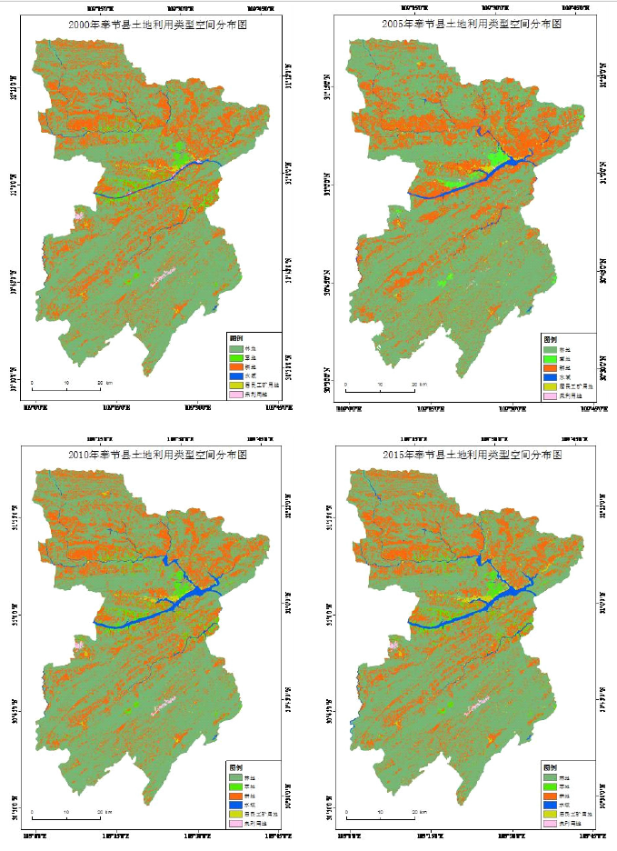
| 类型 | 林地 | 草地 | 耕地 | 水域 | 居民工矿用地 | 未利用地 | 综合土地利用动态态度 | 熵值 | 均衡度 | 优势度 | |
|---|---|---|---|---|---|---|---|---|---|---|---|
| 2000年 | 面积/km2 | 2724.54 | 130.33 | 1151.11 | 36.72 | 26.30 | 12.10 | 4.72 | 0.83 | 0.46 | 0.54 |
| 占比/% | 66.76 | 3.19 | 28.21 | 0.90 | 0.64 | 0.30 | |||||
| 2005 | 面积/km2 | 2756.55 | 128.77 | 1105.52 | 57.12 | 27.30 | 5.83 | 4.71 | 0.83 | 0.46 | 0.54 |
| 占比/% | 67.54 | 3.16 | 27.09 | 1.40 | 0.67 | 0.14 | |||||
| 2000—2005年单一土地利用动态度 | 0.23 | -0.24 | -0.79 | 11.11 | 0.76 | -10.36 | — | — | — | — | |
| 2010年 | 面积/km2 | 2749.27 | 127.79 | 1084.01 | 81.82 | 28.60 | 9.61 | 0.05 | 0.85 | 0.48 | 0.52 |
| 占比/% | 67.37 | 3.13 | 26.56 | 2.00 | 0.70 | 0.24 | |||||
| 2005—2010年单一土地利用动态度 | -0.05 | -0.15 | -0.39 | 8.65 | 0.95 | 12.98 | — | — | — | — | |
| 2015年 | 面积/km2 | 2753.90 | 126.60 | 1072.26 | 83.39 | 35.33 | 9.61 | 0.09 | 0.86 | 0.48 | 0.52 |
| 占比/% | 67.48 | 3.10 | 26.27 | 2.04 | 0.87 | 0.24 | |||||
| 2010—2015年单一土地利用动态度 | 0.03 | -0.19 | -0.22 | 0.38 | 4.71 | 0.00 | — | — | — | — | |
| 2000—2015年单一土地利用动态度 | 0.07 | -0.19 | -0.46 | 8.47 | 2.29 | -1.37 | — | — | — | — | |
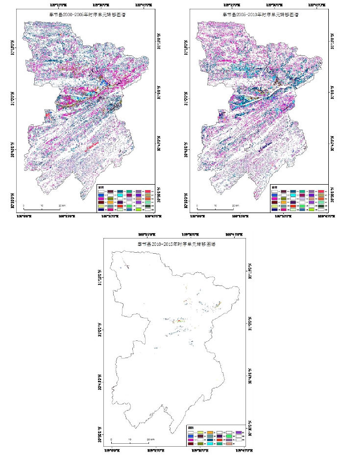
| 年份 | 编码 | 土地利用转移图谱单元 | 图谱单元数/个 | 面积/m2 | 土地利用变化比率/% |
|---|---|---|---|---|---|
| 2000—2005年 | 31 | 耕地→林地 | 582075 | 523.87 | 40.15 |
| 13 | 林地→耕地 | 528209 | 475.39 | 36.44 | |
| 12 | 林地→草地 | 74418 | 66.98 | 5.13 | |
| 23 | 草地→耕地 | 61139 | 55.03 | 4.22 | |
| 21 | 草地→林地 | 57801 | 52.02 | 3.99 | |
| 32 | 耕地→草地 | 44521 | 40.07 | 3.07 | |
| 2005—2010年 | 13 | 林地→耕地 | 566146 | 509.53 | 39.08 |
| 31 | 耕地→林地 | 548940 | 494.05 | 37.89 | |
| 21 | 草地→林地 | 75246 | 67.72 | 5.19 | |
| 32 | 耕地→草地 | 59297 | 53.37 | 4.09 | |
| 12 | 林地→草地 | 57122 | 51.41 | 3.94 | |
| 23 | 草地→耕地 | 43548 | 39.19 | 3.01 | |
| 2010—2015年 | 31 | 耕地→林地 | 9426 | 8.48 | 42.81 |
| 15 | 林地→居民工矿用地 | 3758 | 3.38 | 17.07 | |
| 35 | 耕地→居民工矿用地 | 2949 | 2.65 | 13.39 | |
| 14 | 林地→水域 | 1867 | 1.68 | 8.48 | |
| 21 | 草地→林地 | 1134 | 1.02 | 5.15 | |
| 45 | 水域→居民用地 | 913 | 0.82 | 4.15 |
| 因素 | 指标 |
|---|---|
| 城镇化水平 | X1年末总人口、X2非农业人口、X3城镇化率/% |
| 经济因素 | X4地区生产总值、X5第一产业、X6第二产业、X7第三产业、X8工业、X9农林牧渔业总产值 |
| 农业结构 | X10粮食产量、X11油料产量、X12烟叶产量、X13茶叶产量、X14水果产量、X15蔬菜产量、X16肉类总产量、X17水产品产量 |
| 政策因素 | X18公路里程、X19全社会固定资产投资、X21公共预算收入、X22公共预算支出 |
| 社会发展水平 | X20社会消费品零售总额、X23农民人均纯收入 |
| 因素 | 指标 |
|---|---|
| 城镇化水平 | X1年末总人口、X2非农业人口、X3城镇化率/% |
| 经济因素 | X4地区生产总值、X5第一产业、X6第二产业、X7第三产业、X8工业、X9农林牧渔业总产值 |
| 农业结构 | X10粮食产量、X11油料产量、X12烟叶产量、X13茶叶产量、X14水果产量、X15蔬菜产量、X16肉类总产量、X17水产品产量 |
| 政策因素 | X18公路里程、X19全社会固定资产投资、X21公共预算收入、X22公共预算支出 |
| 社会发展水平 | X20社会消费品零售总额、X23农民人均纯收入 |
| 因子 | 主成分1 | 主成分2 | 因子 | 主成分1 | 主成分2 |
|---|---|---|---|---|---|
| 1 | 0.95 | — | 23 | 0.87 | 0.49 |
| 2 | 0.94 | 0.29 | 13 | 0.86 | 0.49 |
| 7 | 0.94 | 0.26 | 14 | 0.84 | 0.52 |
| 3 | 0.94 | 0.34 | 15 | 0.84 | 0.53 |
| 20 | 0.94 | 0.32 | 6 | 0.83 | 0.54 |
| 21 | 0.94 | 0.27 | 12 | 0.66 | 0.5 |
| 4 | 0.9 | 0.43 | 8 | 0.57 | 0.64 |
| 22 | 0.9 | 0.42 | 10 | 0.35 | — |
| 9 | 0.89 | 0.44 | 11 | 0.3 | 0.9 |
| 19 | 0.89 | 0.44 | 17 | 0.19 | 0.95 |
| 5 | 0.87 | 0.48 | 16 | — | 0.88 |
| [1] | Ellis E C.Anthropogenic transformation of the terrestrial biosphere[J].Philosophical Transactions of the Royal Society A: Mathemati-cal, Physical and Engineering Sciences,2011,369(1938):1010-1035. |
| [2] | Shannon M. Sterling,Agnès Ducharne,Jan Polcher.The impact of global land-cover change on the terrestrial water cycle[J].Nature Climate Change,2013,3(4). |
| [3] |
Jansen L J M,Bagnoli M,Focacci M.Analysis of land-cover/use change dynamics in Manica Province in Mozambique in a period of transition(1990-2004)[J].Forest Ecology and Management,2008,254(2):308-326.
doi: 10.1016/j.foreco.2007.08.017 URL |
| [4] |
Pelorosso R,Leone A,Boccia L.Land cover and land use change in the Italian central apennines: a comparison of assessment methods[J].Applied Geography,2009,29(1):35-48.
doi: 10.1016/j.apgeog.2008.07.003 URL |
| [5] | 刘纪远,匡文慧,张增祥,等.20世纪80年代末以来中国土地利用变化的基本特征与空间格局[J].地理学报,2014,69(1):3-14. |
| [6] | 张俊平,李净.基于CA-Markov模型的甘州区土地利用变化预测分析[J].中国农学通报,2017,33(4):105-110. |
| [7] | 龚文峰,王鑫鑫,曹凯华,等.基于RS和GIS五常市土地利用变化及模拟研究[J].黑龙江大学工程学报,2019,10(2):15-22. |
| [8] | 张译,杨伯钢,王淼,等.京津冀地区林地空间变化及驱动力研究[J].测绘科学,2020,45(9):104-110. |
| [9] | 于天,曹银贵,许婧雪.基于不同尺度的中国耕地变化驱动力研究进展[J].中国农学通报,2016,32(24):194-198. |
| [10] | 吴翠霞,冯永忠,陶卓琳,等.白银市土地利用变化对生态系统服务价值的影响[J].中国农学通报,2020,36(11):74-81. |
| [11] | 张杨,刘艳芳,顾渐萍,等.武汉市土地利用覆被变化与生态环境效应研究[J].地理科学,2011,31(10):1280-1285. |
| [12] | 范树平,刘友兆,程从坤,等.快速城镇化地区土地利用演变及驱动机制——以巢湖流域为例[J].水土保持通报,2017,37(2):253-260. |
| [13] | 张诗晓,张浚茂,张文康,等.泛珠江流域土地利用时空变化特征及驱动因子[J].应用生态学报,2020,31(2):573-580. |
| [14] | 尹娟,柳德江,赵敏慧,等.2000—2014年抚仙湖流域土地利用动态变化研究[J].中国农学通报,2018,34(4):101-107. |
| [15] |
韩冬锐,徐新良,李静,等.长江三角洲城市群热环境安全格局及土地利用变化影响研究[J].地球信息科学学报,2017,19(1):39-49.
doi: 10.3724/SP.J.1047.2017.00039 |
| [16] | 徐丽华,王欢欢,张结存,等.近15年来杭州市土地利用结构的时空演变[J].经济地理,2014,34(7):135-142. |
| [17] |
罗娅,杨胜天,刘晓燕,等.黄河河口镇—潼关区间1998-2010年土地利用变化特征[J].地理学报,2014,69(1):42-53.
doi: 10.11821/dlxb201401004 |
| [18] | 陈佳楠,邓芳,乌恩图,等.浑善达克典型区域沙化土地十年遥感监测分析[J].中国农学通报,2015,31(29):227-234. |
| [19] | 常成,刘霞,张光灿,等.蒙阴县土地利用动态与耕地变化驱动力分析[J].中国水土保持科学,2010,8(1):65-70. |
| [20] | 马姣娇,牛安逸,徐颂军,等.基于地学信息图谱的珠海淇澳岛土地利用格局分析[J].华南师范大学学报:自然科学版,2018,50(2):77-85. |
| [21] | 赵文玥,李阳兵,李媛媛,等.三峡库区腹地撂荒地动态演变及景观格局——以重庆市奉节县平安乡、竹园镇为例[J].水土保持通报,2018,38(3):256-262. |
| [22] | 甘彩红,李阳兵,陈萌萌.基于坡耕地与聚落空间耦合的三峡库区腹地奉节县人地关系研究[J].地理研究,2015,34(7):1259-1269. |
| [23] |
张佰林,高江波,高阳,等.中国山区农村土地利用转型解析[J].地理学报,2018,73(3):503-517.
doi: 10.11821/dlxb201803009 |
| [24] | 奉节县地方志办公室.奉节年鉴[R].团结出版社,2016,98. |
| [25] | 赵阳,余新晓,贾剑波,等.红门川流域土地利用景观动态演变及驱动力分析[J].农业工程学报,2013,29(9):239-248. |
| [26] | 陈磊,孙佳新,姜海,等.南京市土地利用结构时空格局及驱动因素[J].水土保持研究,2020,27(1):197-206. |
| [27] | 李秋萍,陆汝成,梁宝坤,等.广西陆地边境地区土地利用信息图谱构建[J].水土保持研究,2016,23(6):210-215,2. |
| [28] | 徐铖龙,龚文峰,卢玉海,等.基于土地利用信息图谱的西南区县域土地利用时空演变分析——以重庆市奉节县为例[J].黑龙江水利科技,2020,48(9):25-28. |
| [29] | 陈菁,谢晓玲.海峡西岸快速城市化中土地利用变化的影响因素[J].经济地理,2010,30(11):1885-1889. |
| [1] | LU Qianqian, FENG Linjiao, WANG Shuang, GULIZHATI·Baoerhan , CHU Ren, ZHOU Long. Effects of Compound Saline-alkali Stress on Physiological and Biochemical Indexes of Table Grapes [J]. Chinese Agricultural Science Bulletin, 2023, 39(1): 62-70. |
| [2] | LIU Cuilan, WANG Kaifang, WU Dejun, YAN Liping, LI Shanwen, WANG Fang, REN Fei, WANG Yinhua. Responses of Growth and Physiological Characteristics of Fraxinus Clones to Coastal Saline-Alkaline Stress [J]. Chinese Agricultural Science Bulletin, 2022, 38(35): 7-16. |
| [3] | YU Zhonghao, ZHOU Wei, LI Zhigang, LI Ziwen, JIA Juanxia, ZHOU Yaxing. Analysis and Comprehensive Evaluation of Main Traits of Soybean in Inner Mongolia from 2002 to 2021 [J]. Chinese Agricultural Science Bulletin, 2022, 38(34): 14-21. |
| [4] | LU Mengyao, LIU Dehu, LU Xueli, LIANG Heng, SUN Yuanyuan, LIU Yalin, SONG Tingqiang, FAN Haisheng. Construction of Flood Disaster Risk Assessment Model Based on Principal Component Analysis in Hubei Province [J]. Chinese Agricultural Science Bulletin, 2022, 38(32): 119-127. |
| [5] | LUO Wei, ZHOU Wei, WANG Zhenguo, LI Yan, YU Wenhao, YANG Zhiqiang, YU Zhonghao, LI Ziwen, ZHOU Yaxing. Twenty-four Sweet Sorghum Materials: Comprehensive Analysis of Main Agronomic Traits and Biological Yield [J]. Chinese Agricultural Science Bulletin, 2022, 38(30): 21-28. |
| [6] | ZHAO Lijuan, ZHI Jiazeng, ZHANG Jianchun, DU Hao, ZHOU Jinsong, LIU Xuemin, ZHANG Rongqin. Diversity Analysis of Leaf Phenotypic Characters of Musa spp. Germplasms [J]. Chinese Agricultural Science Bulletin, 2022, 38(30): 56-64. |
| [7] | LIU Zifan, SU Bimeng, HUANG Jie, WEI Yunxia, XIAO Zili. Effects of Cassava-Peanut Intercropping Patterns on Soil Fertility [J]. Chinese Agricultural Science Bulletin, 2022, 38(25): 102-107. |
| [8] | WANG Zhiqiang, DU Huiying, LI Cheng, GUO Song, TIAN Mei, YANG Wanbang, YU Rong. Genetic Distance and Heterosis of Quantitative Characters of Watermelon [J]. Chinese Agricultural Science Bulletin, 2022, 38(25): 47-51. |
| [9] | LUO Yulan, ZHANG Guobing, ZHANG Dongmei. Study on Cultivar Classification of Wisteria According Morphological Characteristics [J]. Chinese Agricultural Science Bulletin, 2022, 38(25): 52-59. |
| [10] | YAO Xiaojian, ZHANG Xiongjian, YAO Zhufang, LUO Zhongxia, WANG Zhangying, HUANG Lifei, FANG Boping, YANG Yiling. Potted Conservation Substrates of Sweet Potato Germplasms: Screening and Evaluation [J]. Chinese Agricultural Science Bulletin, 2022, 38(24): 28-37. |
| [11] | ZHANG Mengfei, LI Shuang, LI Yunsheng, MA Haixia, LIU Yueqiu. Evaluation on the Drought Resistance of Seedlings of Nine Greening Tree Species [J]. Chinese Agricultural Science Bulletin, 2022, 38(20): 38-46. |
| [12] | LIU Yupeng, ZHANG Hao, CHEN Fang, YU Fei. Effects of Sowing Date on Yield and Quality of Pepper [J]. Chinese Agricultural Science Bulletin, 2022, 38(16): 32-37. |
| [13] | ZHU Mingxia, BAI Ting, JIN Yulong, WANG Shanshan, LIU Xiaojiao, ZHANG Yuhong. Analysis of Flavor Substances of Different Highland Barley Varieties [J]. Chinese Agricultural Science Bulletin, 2022, 38(12): 146-152. |
| [14] | Guo Juncheng, Wang Mingguo, Geng Rong, Li Xin, Yin Xuehong, Wei Guning. Salinity Characteristics Analysis of Saline Alkali Soil in Yinbei Irrigation District of Ningxia [J]. Chinese Agricultural Science Bulletin, 2021, 37(5): 38-42. |
| [15] | Su Xinxin, Xiao Yang, Hu Xiaohang, Ma Yahuai, Li Yanli. The Adaptability Evaluation of Sugar Beet Varieties Based on Grey Relational Analysis and Principal Component Analysis [J]. Chinese Agricultural Science Bulletin, 2021, 37(30): 39-46. |
| Viewed | ||||||
|
Full text |
|
|||||
|
Abstract |
|
|||||