Welcome to Chinese Agricultural Science Bulletin,
Chinese Agricultural Science Bulletin ›› 2023, Vol. 39 ›› Issue (10): 101-112.doi: 10.11924/j.issn.1000-6850.casb2022-0276
Special Issue: 农业气象
Previous Articles Next Articles
CHU Yue1( ), XUE Xiaoping2, ZHANG Lijuan1(), HUANG Yutao1, WANG Nan1, WANG Nan1, JIANG Meiyi1, WANG Yumeng1, GUO Xihui1, YANG Yiping1, ZHAO Yufeng1, ZHAO Enbo1
Received:2022-04-08
Revised:2023-06-08
Online:2023-04-05
Published:2023-03-27
CHU Yue, XUE Xiaoping, ZHANG Lijuan, HUANG Yutao, WANG Nan, WANG Nan, JIANG Meiyi, WANG Yumeng, GUO Xihui, YANG Yiping, ZHAO Yufeng, ZHAO Enbo. Risk Assessment and Zoning of Drought Disasters in Shandong Province[J]. Chinese Agricultural Science Bulletin, 2023, 39(10): 101-112.
Add to citation manager EndNote|Ris|BibTeX
URL: https://www.casb.org.cn/EN/10.11924/j.issn.1000-6850.casb2022-0276


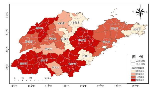


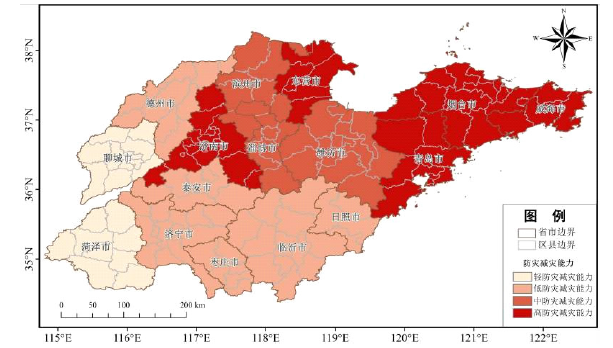

| 地区 | 高风险性 | 中风险性 | 低风险性 | 轻风险性 | |||||||
|---|---|---|---|---|---|---|---|---|---|---|---|
| 面积/km2 | 比例/% | 面积/km2 | 比例/% | 面积/km2 | 比例/% | 面积/km2 | 比例/% | ||||
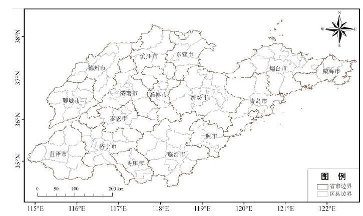
| 滨州市 | 86.7 | 0.90 | 5801.62 | 60.41 | 3664.29 | 38.15 | 51.88 | 0.54 | |||
| 德州市 | 10034.57 | 94.81 | 542.22 | 5.12 | 7.12 | 0.07 | 0 | 0 | |||
| 东营市 | 0 | 0 | 15.26 | 0.21 | 224.82 | 3.14 | 6920.64 | 96.65 | |||
| 菏泽市 | 11798.55 | 97.55 | 290.95 | 2.41 | 5.09 | 0.04 | 0 | 0 | |||
| 济南市 | 39.67 | 0.38 | 3535.09 | 33.68 | 6344.85 | 60.44 | 577.82 | 5.50 | |||
| 济宁市 | 1939.98 | 17.32 | 8405.88 | 75.06 | 839.27 | 7.49 | 13.22 | 0.12 | |||
| 聊城市 | 8092.56 | 92.50 | 656.15 | 7.50 | 0 | 0 | 0 | 0 | |||
| 临沂市 | 815.87 | 4.73 | 6700.90 | 38.85 | 9636.81 | 55.88 | 92.57 | 0.54 | |||
| 青岛市 | 0 | 0 | 107.83 | 0.96 | 10660.20 | 95.32 | 416.07 | 3.72 | |||
| 日照市 | 0 | 0 | 59.00 | 1.10 | 2461.85 | 45.90 | 2842.31 | 53.00 | |||
| 泰安市 | 21.36 | 0.27 | 5245.16 | 66.45 | 2625.63 | 33.26 | 1.02 | 0.01 | |||
| 威海市 | 0 | 0 | 50.86 | 0.90 | 5248.21 | 93.17 | 333.67 | 5.92 | |||
| 潍坊市 | 473.04 | 2.93 | 15229.88 | 94.36 | 409.97 | 2.54 | 26.45 | 0.16 | |||
| 烟台市 | 0 | 0 | 1192.27 | 8.59 | 10287.87 | 74.09 | 2404.88 | 17.32 | |||
| 枣庄市 | 0 | 0 | 62.05 | 1.36 | 3304.16 | 72.50 | 1191.25 | 26.14 | |||
| 淄博市 | 21.36 | 0.35 | 4119.02 | 67.40 | 1966.43 | 32.18 | 4.07 | 0.07 | |||
| 地区 | 高风险性 | 中风险性 | 低风险性 | 轻风险性 | |||||||
|---|---|---|---|---|---|---|---|---|---|---|---|
| 面积/km2 | 比例/% | 面积/km2 | 比例/% | 面积/km2 | 比例/% | 面积/km2 | 比例/% | ||||
| 滨州市 | 86.7 | 0.90 | 5801.62 | 60.41 | 3664.29 | 38.15 | 51.88 | 0.54 | |||
| 德州市 | 10034.57 | 94.81 | 542.22 | 5.12 | 7.12 | 0.07 | 0 | 0 | |||
| 东营市 | 0 | 0 | 15.26 | 0.21 | 224.82 | 3.14 | 6920.64 | 96.65 | |||
| 菏泽市 | 11798.55 | 97.55 | 290.95 | 2.41 | 5.09 | 0.04 | 0 | 0 | |||
| 济南市 | 39.67 | 0.38 | 3535.09 | 33.68 | 6344.85 | 60.44 | 577.82 | 5.50 | |||
| 济宁市 | 1939.98 | 17.32 | 8405.88 | 75.06 | 839.27 | 7.49 | 13.22 | 0.12 | |||
| 聊城市 | 8092.56 | 92.50 | 656.15 | 7.50 | 0 | 0 | 0 | 0 | |||
| 临沂市 | 815.87 | 4.73 | 6700.90 | 38.85 | 9636.81 | 55.88 | 92.57 | 0.54 | |||
| 青岛市 | 0 | 0 | 107.83 | 0.96 | 10660.20 | 95.32 | 416.07 | 3.72 | |||
| 日照市 | 0 | 0 | 59.00 | 1.10 | 2461.85 | 45.90 | 2842.31 | 53.00 | |||
| 泰安市 | 21.36 | 0.27 | 5245.16 | 66.45 | 2625.63 | 33.26 | 1.02 | 0.01 | |||
| 威海市 | 0 | 0 | 50.86 | 0.90 | 5248.21 | 93.17 | 333.67 | 5.92 | |||
| 潍坊市 | 473.04 | 2.93 | 15229.88 | 94.36 | 409.97 | 2.54 | 26.45 | 0.16 | |||
| 烟台市 | 0 | 0 | 1192.27 | 8.59 | 10287.87 | 74.09 | 2404.88 | 17.32 | |||
| 枣庄市 | 0 | 0 | 62.05 | 1.36 | 3304.16 | 72.50 | 1191.25 | 26.14 | |||
| 淄博市 | 21.36 | 0.35 | 4119.02 | 67.40 | 1966.43 | 32.18 | 4.07 | 0.07 | |||


| [1] |
doi: 10.1038/nature11575 |
| [2] |
李芬, 于文金, 张建新, 等. 干旱灾害评估研究进展[J]. 地理科学进展, 2011, 30(7):891-896.
|
| [3] |
周丹, 张勃, 罗静, 等. 基于SPEI的华北地区近50年干旱发生强度的特征及成因分析[J]. 自然灾害学报, 2014, 23(4):192-202.
|
| [4] |
沙莎, 王勇, 沈新勇, 等. 基于SPEI指数的东北春旱频率变化及突变成因分析[J]. 自然灾害学报, 2017, 26(4):180-190.
|
| [5] |
倪深海, 顾颖, 彭岳津, 等. 近七十年中国干旱灾害时空格局及演变[J]. 自然灾害学报, 2019, 28(6):176-181.
|
| [6] |
doi: 10.1038/nclimate1811 |
| [7] |
doi: 10.1016/j.jhydrol.2016.01.003 URL |
| [8] |
doi: 10.1038/nature23021 URL |
| [9] |
文彦君, 方修琦, 李屹凯, 等. 华北地区1876-1879年旱灾研究文献综述[J]. 灾害学, 2019, 34(1):172-180.
|
| [10] |
赵映慧, 郭晶鹏, 毛克彪, 等. 1949—2015年中国典型自然灾害及粮食灾损特征[J]. 地理学报, 2017, 72(7):1261-1276.
doi: 10.11821/dlxb201707011 |
| [11] |
张有智, 解文欢, 吴黎, 等. 农业干旱灾害研究进展[J]. 中国农业资源与区划, 2020, 41(9):182-188.
|
| [12] |
IPCC. Climate change 2014: Mitigation of climate change[M]. United Kingdom: Cambridge University Press, 2015.
|
| [13] |
韩兰英, 张强, 程英, 等. 农业干旱灾害风险研究进展及前景分析[J]. 干旱区资源与环境, 2020, 34(6):97-102.
|
| [14] |
张继权, 李宁. 主要气象灾害风险评价与管理的数量化方法及其应用[M]. 北京: 北京师范大学出版社, 2007.
|
| [15] |
黄崇福. 自然灾害风险分析与管理[M]. 北京: 科学出版社, 2012.
|
| [16] |
张钛仁, 李茂松, 潘双迪, 等. 气象灾害风险管理[M]. 北京: 气象出版社, 2014.
|
| [17] |
梅茹玉, 毛克彪, 杜宝裕, 等. 河北省冬小麦—夏玉米干旱灾害风险评估[J]. 中国农业资源与区划, 2022(7):43.
|
| [18] |
王平. 基于地理信息系统的自然灾害区划的方法研究[J]. 北京师范大学学报(自然科学版), 2000(3):410-416.
|
| [19] |
doi: 10.1007/s11069-007-9191-5 URL |
| [20] |
doi: 10.1016/j.jher.2013.07.003 URL |
| [21] |
|
| [22] |
李万志, 张调风, 马有绚, 等. 基于灾害风险因子的青海省干旱灾害风险区划[J]. 干旱气象, 2021, 39(3):480-485,493.
|
| [23] |
李娜, 霍治国, 钱锦霞, 等. 山西省干旱灾害风险评估与区划[J]. 中国农业资源与区划, 2021, 42(5):100-107.
|
| [24] |
王理萍, 王树仿, 王新华, 等. 基于AHP和GIS的云南省干旱灾害风险区划研究[J]. 节水灌溉, 2017(10):100-103,106.
|
| [25] |
徐玉霞, 许小明, 杨宏伟, 等. 基于GIS的陕西省干旱灾害风险评估及区划[J]. 中国沙漠, 2018, 38(1):192-199.
|
| [26] |
张存杰, 王胜, 宋艳玲, 等. 我国北方地区冬小麦干旱灾害风险评估[J]. 干旱气象, 2014, 32(6):883-893.
doi: 10.11755/j.issn.1006-7639(2014)-06-0883 |
| [27] |
高操, 陈希, 张方敏, 等. 基于GIS的沧州市小麦干旱气象灾害风险评估[J]. 安徽农业科学, 2019, 47(21):223-226.
|
| [28] |
胡亚南. 华北冬小麦—夏玉米轮作区干旱灾害风险评估[D]. 北京: 中国农业科学院, 2013.
|
| [29] |
吴东丽, 王春乙, 薛红喜, 等. 华北地区冬小麦干旱风险区划. 生态学报, 2011, 31(3):760-769.
|
| [30] |
杨平, 张丽娟, 赵艳霞, 等. 黄淮海地区夏玉米干旱风险评估与区划[J]. 中国生态农业学报, 2015, 23(1):110-118.
|
| [31] |
李佳. 贵州省玉米干旱灾害风险评估[D]. 郑州: 华北水利水电大学, 2016.
|
| [32] |
单琨, 刘布春, 刘园. 基于自然灾害系统理论的辽宁省玉米干旱风险分析[J]. 农业工程学报, 2012, 28(8):186-194.
|
| [33] |
姜德娟, 李志, 王昆. 1961—2008年山东省极端降水事件的变化趋势分析[J]. 地理科学, 2011, 31(9):1118-1124.
|
| [34] |
王庆, 马倩倩, 夏艳玲, 等. 最近50年来山东地区夏季降水的时空变化及其影响因素研究[J]. 地理科学, 2014, 34(2):220-228.
doi: 10.13249/j.cnki.sgs.2014.02.220 |
| [35] |
王正东, 郭鹏, 万红, 等. 基于MODIS数据的山东省2014—2016年干旱监测分析[J]. 水土保持研究, 2019, 26(2):330-336.
|
| [36] |
李会群, 王文. 基于相对湿润度指数的山东省作物生长季干旱特征[J]. 干旱区资源与环境, 2015, 29(11):191-196.
|
| [37] |
苏喆, 廉丽姝, 刘元月, 等. 基于SPI的1960—2018年山东省冬小麦生长期干旱时空特征分析[J]. 曲阜师范大学学报(自然科学版), 2021, 47(1):99-106.
|
| [38] |
王兆雪. 基于遥感的山东省旱情监测及干旱指数适用性分析研究[D]. 青岛: 青岛大学, 2020.
|
| [39] |
杨丽. 山东省小麦玉米干旱指数保险研究[D]. 南京: 南京信息工程大学, 2013.
|
| [40] |
姜甜甜. 基于农业保险风险区划的山东省小麦干旱指数保险研究[D]. 济南: 山东财经大学, 2016.
|
| [41] |
李哲东. 山东省花生干旱指数保险定价研究[D]. 贵阳: 贵州财经大学, 2016.
|
| [42] |
童德明, 白雲, 张莎, 等. 干旱严重程度指数(DSI)在山东省干旱遥感监测中的适用性[J]. 中国农业气象, 2020, 41(2):102-112.
|
| [43] |
杜桂河, 陈燕, 杜晓惠. 山东省近几年干旱时空分布特征分析[J]. 山东水利, 2017(4):3-4.
|
| [44] |
朱秀红. 山东省干旱特征分析[A].//中国气象学会2007年年会气候学分会场论文集[C]. 2007:1121-1124.
|
| [45] |
张继权, 梁警丹, 周道玮. 基于GIS技术的吉林省生态灾害风险评价[J]. 应用生态学报, 2007(8):1765-1770.
|
| [46] |
谷亚超, 于利武, 代庆. 干旱分类及常用计算方法概述[J]. 东北水利水电, 2011, 29(5):37-39.
|
| [47] |
马蒙蒙. 近60年山东省干旱时空分布特征分析[D]. 济南: 济南大学, 2020.
|
| [48] |
童德明. 基于遥感数据的山东干旱特征分析[D]. 青岛: 青岛大学, 2020.
|
| [1] | ZHANG Qiulu. A Comprehensive Evaluation of the Colored-leaf Tree Species Introduced to the Huai’an Section of Beijing-Hangzhou Grand Canal Based on Analytic Hierarchy Process [J]. Chinese Agricultural Science Bulletin, 2023, 39(8): 15-20. |
| [2] | SONG Hongen, JIANG Changyi, LI Shuchao, SUN Zhaoming. Measurement and Analysis of Carbon Emissions of Shandong Planting Industry [J]. Chinese Agricultural Science Bulletin, 2023, 39(8): 43-50. |
| [3] | QI Kangkang, ZHAO Jia, WANG Limin, FAN Yangyang, HOU Xuehui, RUAN Huaijun. Innovation Strategy of Major Key Technologies of Intelligent Agricultural Machinery Equipment in Shandong [J]. Chinese Agricultural Science Bulletin, 2023, 39(5): 1-5. |
| [4] | ZHANG Xia, XU Xiumei. Influencing Factors of Agricultural Technology Extension Efficiency——A Case Study of Pingdu City, Shandong Province [J]. Chinese Agricultural Science Bulletin, 2022, 38(30): 135-140. |
| [5] | CHENG Hongyan, ZHANG Lanying, WANG Feng, DU Zhenyu. Soil Physicochemical Characteristics and Comprehensive Fertility of Pinus densiflora Artificial Forests in Shandong Province [J]. Chinese Agricultural Science Bulletin, 2022, 38(23): 70-76. |
| [6] | LIANG Yan, HAN Chuanming, ZHOU Jilei, SUN Chao, WANG Cuixiang, LI Chunming, WANG Jing, MIN Xufeng, GONG Qingdang, MENG Xiaoye, YANG Xuqiang. Construction of SSR Fingerprint and Molecular Identity Card of Shandong Elite Julans regia Cultivars—Based on Capillary Electrophoresis Analysis [J]. Chinese Agricultural Science Bulletin, 2022, 38(15): 113-121. |
| [7] | XIE Linxiao, DUAN Yifang, XIAO Chaofei, LI Jinlong. The Coupling Coordination Degree of Land Use Ecology-Society-Economy System in Shandong Province: Spatial-temporal Evolution and Obstacle Factor Analysis [J]. Chinese Agricultural Science Bulletin, 2022, 38(12): 61-68. |
| [8] | NI Shenhai, WANG Hengli, LIU Jingnan, GU Ying. Characteristics and Causes of Agricultural Drought Disasters in China [J]. Chinese Agricultural Science Bulletin, 2022, 38(10): 106-111. |
| [9] | Duan Youchun. Spatial Variability Characteristics and Influencing Factors of Soil Nutrients in Farmland in Typical Hilly and Plain Area of Southeast Shandong [J]. Chinese Agricultural Science Bulletin, 2021, 37(23): 61-68. |
| [10] | Zhang Chunyan, Wu Ronghua, Zhuang Kezhang, Xu Jie, Li Xinxin, Li Jing, Wang Heng, Qi Xiaofeng. Comprehensive Evaluation of Maize Varieties in Southern Shandong Province by DTOPSIS Method Based on Entropy Weight [J]. Chinese Agricultural Science Bulletin, 2021, 37(23): 8-14. |
| [11] | Chen Chunyan, Lin Zhengyu, Liu Yuanli, Gao Wenbo. The Development Path of Agricultural and Rural Urbanization in Chengdu-Deyang-Meishan-Ziyang [J]. Chinese Agricultural Science Bulletin, 2021, 37(19): 151-157. |
| [12] | Huang Haitao, Ao Cun, Mao Yuxiao, Yu Jizhong, Zhang Wei. Comprehensive Evaluation on Characters of Tea Varieties Suitable for Longjing Tea: Based on Multiple Statistic [J]. Chinese Agricultural Science Bulletin, 2020, 36(4): 76-82. |
| [13] | Wang Pan, Liu Ya, Zhou Yuhong, Wang Kangmin, Chen Zilin. Evaluation of Edible Exploitation Value of Wild Fruits Resources in Dapanshan National Natural Reserve [J]. Chinese Agricultural Science Bulletin, 2020, 36(25): 26-31. |
| [14] | Lv Zihe, Ding Songshuang, Lu Ruilin. Climate Suitability of Crops in China: Research Progress [J]. Chinese Agricultural Science Bulletin, 2020, 36(24): 78-84. |
| [15] | Guo Fangqi, Hei Yinxiu, Liu Jun, Wu Chao, Ye Qiming, Zhang Zhi. Spray Cut Chrysanthemum: Evaluation of Quality Characters by AHP [J]. Chinese Agricultural Science Bulletin, 2020, 36(17): 51-56. |
| Viewed | ||||||
|
Full text |
|
|||||
|
Abstract |
|
|||||